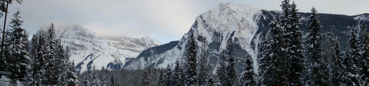

Powderface Ridge in Kananaskis, Alberta is a tough slog both up and down but the top has amazing views
I had heard a lot about this trail, researched this trail, and downloaded off-line maps for it for my GPS and static maps in case that failed. Turns out, I should have gone one step further and taken someone along who knew the correct route.
It is on the edge of the Rockies and the top has an amazing view of the peaks in the distance.
The 8 km up is relentless. It has 700m vertical of rocky trails of mostly even grade. There was virtually no running this trail. It was mostly a fast hike to the top.

I had planned to run on the way down, so I could make up time. In my misguided wisdom, I thought I would hike up the one side, down the other side, back up the other side and and then downhill all the way back to the car.
I got to the top, ooh-ed and awe-d, and then started on the way down the other side. However, I must have immediately lost the trail. What I was following looked like a trail, and followed the rock cairns along the top and was going in the right direction. Evidently other people must have taken this trail too, but had obviously judged the error of their ways and corrected before I noticed my error.


On the way down, when I checked on my GPS 500m after the top, it showed the official trail was 100m to the east, fortunately going the same direction as I was. However, it was down a steep cliff from where I was. And that cliff continued for another 500m (forward and back). I never was able to get over to the trail. So I ended up picking my way down the mountain through the trees making my own trail. Not so smart since it took me an hour to go 2 km to the highway at 30%+ grades. At the bottom I was only 200m from the trailhead I had wanted to go down.
But I had lost too much time and had to find a quicker way home. So instead of going back up and over the mountain, having briefly contemplated hitch-hiking, I ran the 9km along the highway back to my car.


I had wanted to do the 700m x 2 = 1400m vertical, but I only got in 900m for the day. Still it was a 4 hour trail run (mostly a hike). Still an epic place to be on a beautiful Saturday afternoon. What more could I want?
Next time I’ll know the trail a lot better. But the fun is in the adventure, right?
Instagram of amazing trails: @trail_runner_guy
More mountain climbing stories here: Ha Ling Peak, Epic Trail Running, Kananaskis, Galatea Creek, Jasper, Hamilton Lake, Powderface Ridge

What kind of GPS are you using. I just use the iPhone and often wonder what the loss rate would be in the wilderness.
LikeLiked by 1 person
My phone GPS is only a couple meters out of accurate. Works pretty good.
LikeLiked by 1 person
I did notice the the GPS on the iPhone 5 I just got is more Accurate then the 4S I have.
LikeLiked by 1 person
The overlay over the Google maps is very accurate. I rely on it and it works well
LikeLiked by 1 person